Shafter Silver Project
Project Overview
The Shafter Project is located in Presidio County, Texas, near the town of Marfa. The Project is situated within a basin carbonate sequence that extends 1,600km from northern Mexico through southwest Texas, and lies in an extension of Mexico’s Eastern Sierra Madre Belt which is home to Penasquito, the world's fifth largest silver-producing mine, operated by Newmont (Figure 1).
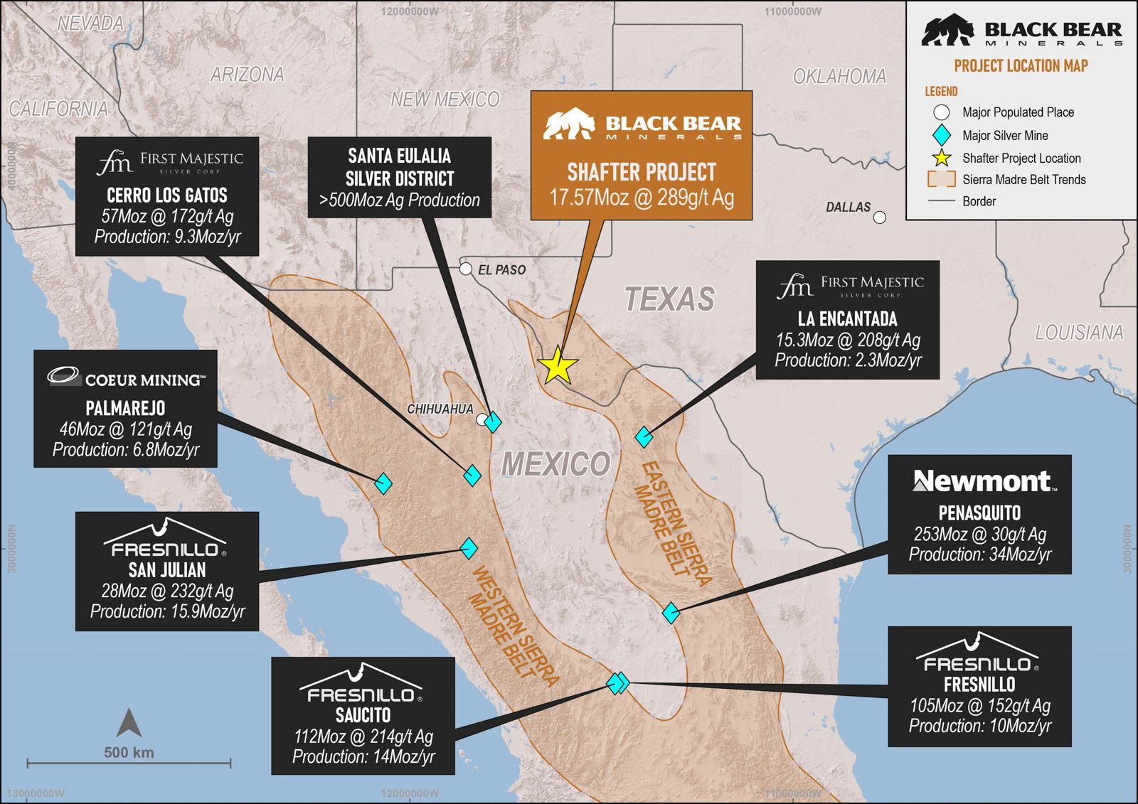
Figure 1: Location of Shafter Project in relation to major silver mines of the Sierra Madre Belt.
Marfa, 64km north of the Project, with a population of approximately 1,800, serves as a local administrative hub and is known for its focus on arts and culture, ranching, and tourism. Presidio, 32km south with a population around 4,100, plays an important role as an administrative centre for US Border Patrol operations, as well as supporting agriculture, ranching, tourism, and transportation.
The mineralised zone at Shafter spans approximately 4 kilometres of strike from west to east, and gently dipping eastward (Figure 2). The western portion outcrops at surface and was historically worked as the Presidio Mine, which operated from 1883 until its closure in 1942 due to declining silver prices and war time legislation. During that period, the mine produced approximately 2.3 million tons of ore containing 35.2 million ounces of silver, averaging 521 g/t Ag. The historic Presidio Mine workings include 160km of underground drifts, declines, adits, and stopes, along with four production shafts.
Aurcana Silver Corporation (formerly listed on the TSX-V) acquired the Project in 2008 (through its subsidiaries Rio Grande Mining Company and Shafter Properties Inc.), conducting additional drilling and resource classification work prior to building new processing facilities. Aurcana commenced production in 2012 and operated until December 2013, when operations ceased due to a significant drop in the silver price to US$18.19 oz Ag. Aurcana produced 134,557oz Ag in 2012–2013 primarily from a starter open pit and limited cutbacks on Presidio Mine workings.
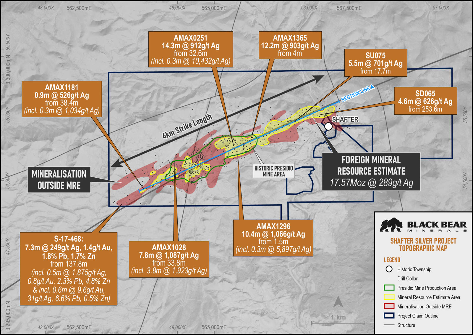
Figure 2: Shafter Project showing mineralisation outline, historic Presidio Mine and drill collars , Section Line A within Figure 9.
Infrastructure
In 2012, a mill, refinery, warehousing, and administrative facilities were constructed. The warehouse complex covers 24,000 square feet and includes key infrastructure, such as a maintenance shop, dry storage, assay laboratory, administration offices, mill process units, mill offices, and a Merrill-Crowe plant and refinery.
Site Buildings
- 2,230m² warehouse complex, which houses the maintenance and truck shop (557m²), the warehouse (1,115m²), and the assay laboratory (557m²)
- 981m² administrative building, which house the offices, first aid and training room, as well as a data room to compile operations records
- 1,370m² mill process unit
- 250m² Merrill-Crowe recovery plant and refinery
- A hoist building and two core sheds near the Gold Fields shaft in good usable condition
Power
A regional 69 kV utility-owned power line connects to the on-site substation (as shown in figure 5) and power is distributed to various points on the property via 11 kV overhead power lines where it will be stepped down to 4,160 VAC and lower voltages as required.
Water Rights
Full unincumbered water rights for exploration, development and any potential future operations.
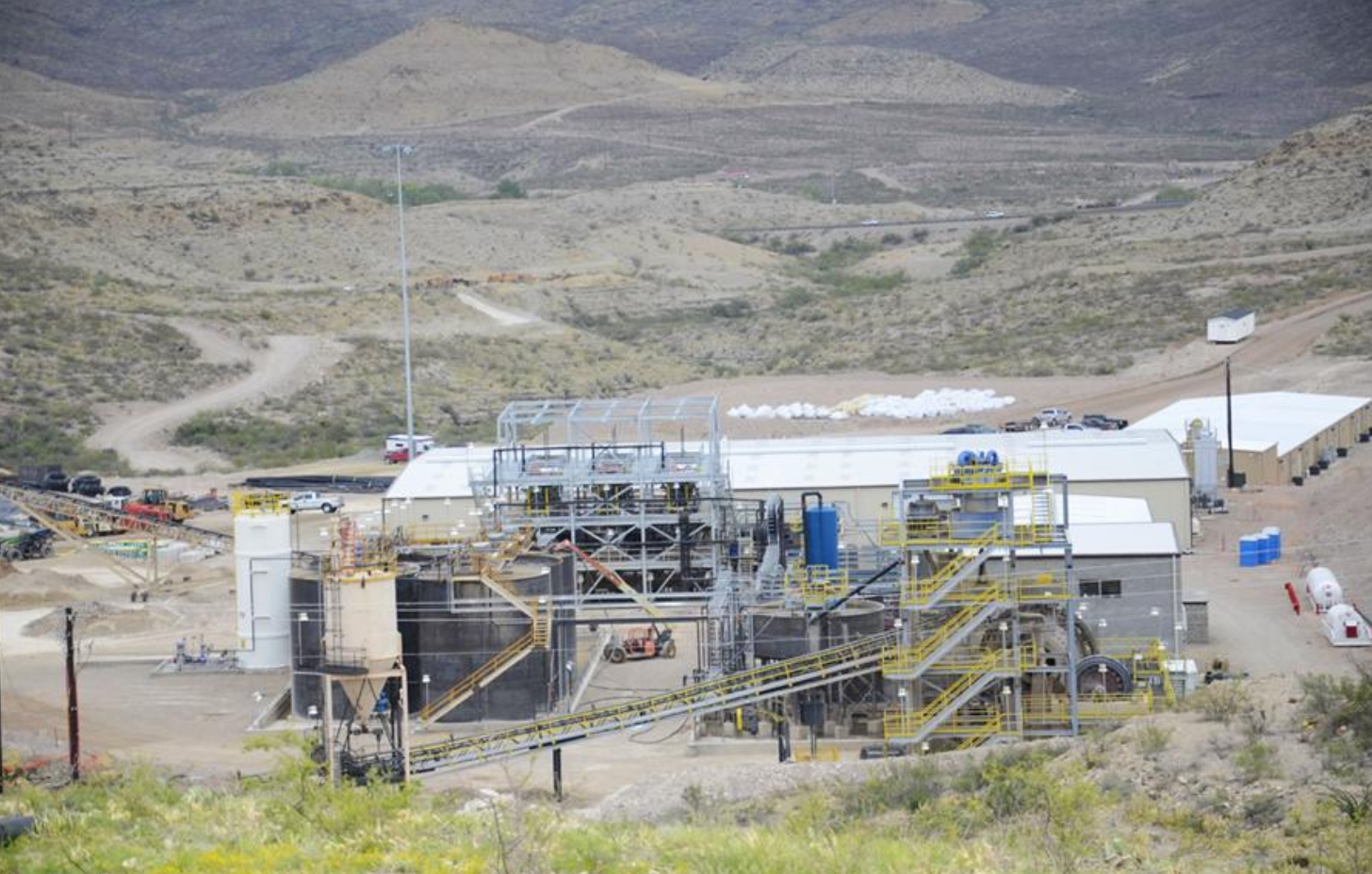
Figure 3: Shafter Processing Infrastructure.
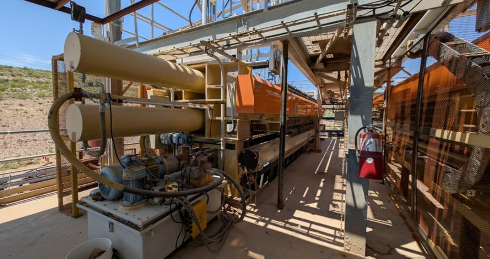
Figure 4: Shafter Processing Facility Filter Press (one of two filter press’).

Figure 5: Shafter Mine and Processing Substation.
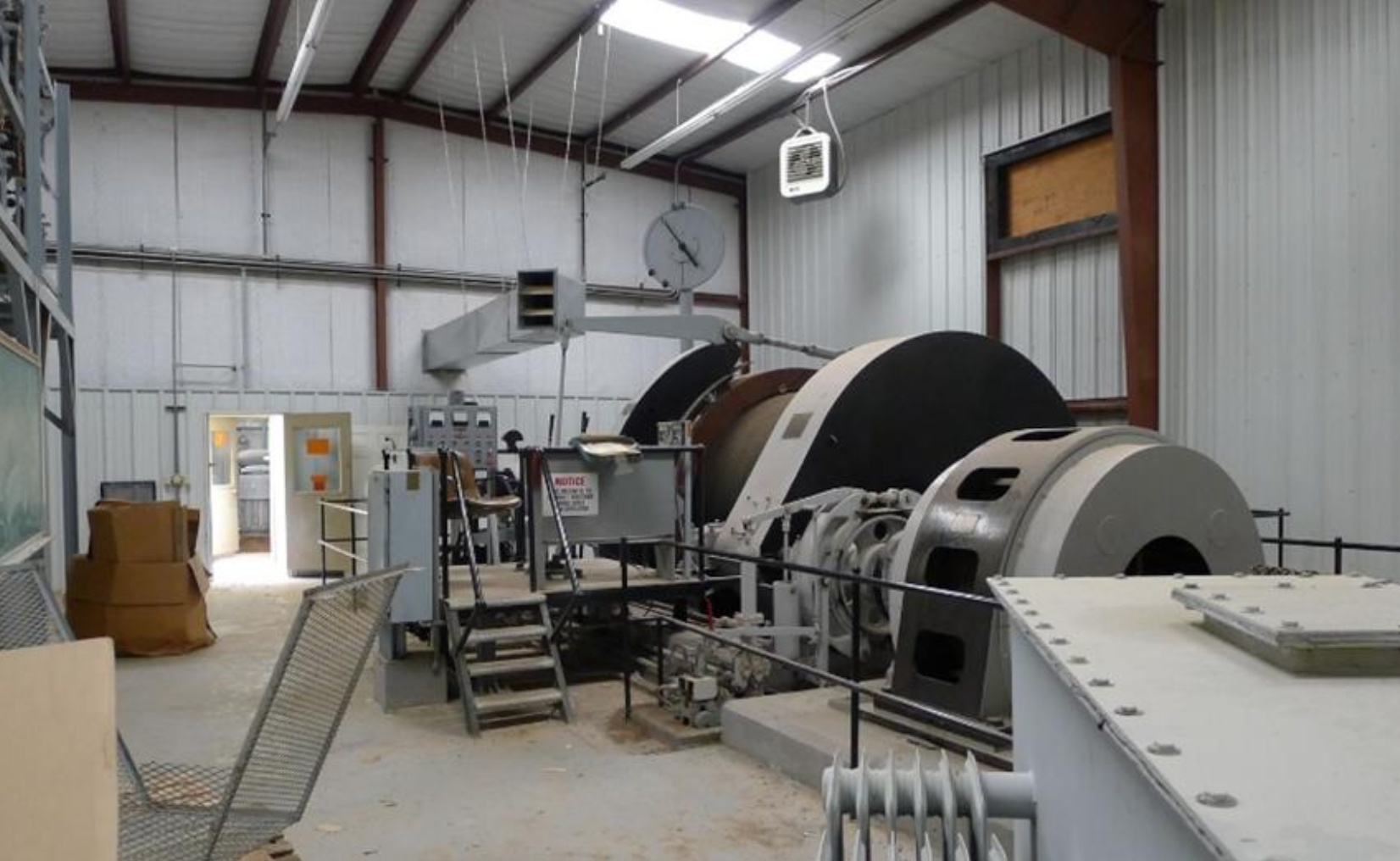
Figure 6: Underground Mine Winch.
Figure 7: Shafter Underground Decline (left), and Core Storage Facility (right)
Geology and Mineralisation
The geology within southwest Texas comprises a sequence of Jurassic-Cretaceous sedimentary basin rocks overlain by older Paleozoic basement. The sedimentary carbonate sequence extends over 1,600km from northern Mexico, through southwestern Texas, to southeastern Arizona, and were thrust faulted and folded during the Laramide orogeny. Silver-lead-zinc deposits, including the Shafter deposit, occur across the strike of the carbonate sequences, though little attention has been historically focused outside Mexico.
The Shafter mining district is located on the south flank of the Chinati Mountains, adjacent to a Tertiary age volcanic caldera. Outcrops in the district are predominantly Permian and Cretaceous limestone, dolomite, siltstone, and sandstone, that were uplifted during the Cretaceous-Tertiary Laramide orogeny and were later cut by Tertiary intrusions.
The mineralised zones in the Shafter district occur mainly as replacement bodies along bedding planes in the upper Permian limestone, directly below the unconformable contact with the base of the Cretaceous sequence. Mineralised zones, termed ‘mantos’, are generally parallel to bedding and dip gently southeast.Manto thickness is generally 2.5 – 4.5m, increasing where near-vertical ‘feeder’ structures dissect.
The global Shafter mineralised zone is up to 450m wide in a north-south direction and extends at least 4km on a northeast trend. Silver is present predominately as oxidized acanthite in aggregates of quartz, calcite, and goethite, with lesser dolomite, hemimorphite, willemite, anglesite, galena, smithsonite, and sphalerite.
The Shafter Mineralisation broadly follows the trend of the MacDaniel Fault, which is thought to be a major feeder structure for mineralisation. Recent work by Gold Fields and Aurcana focussed on defining mineralisation along strike to the northeast of the historic Presidio Mine, defining a 1.8km mineralised zone termed the ‘Shafter Extension’.
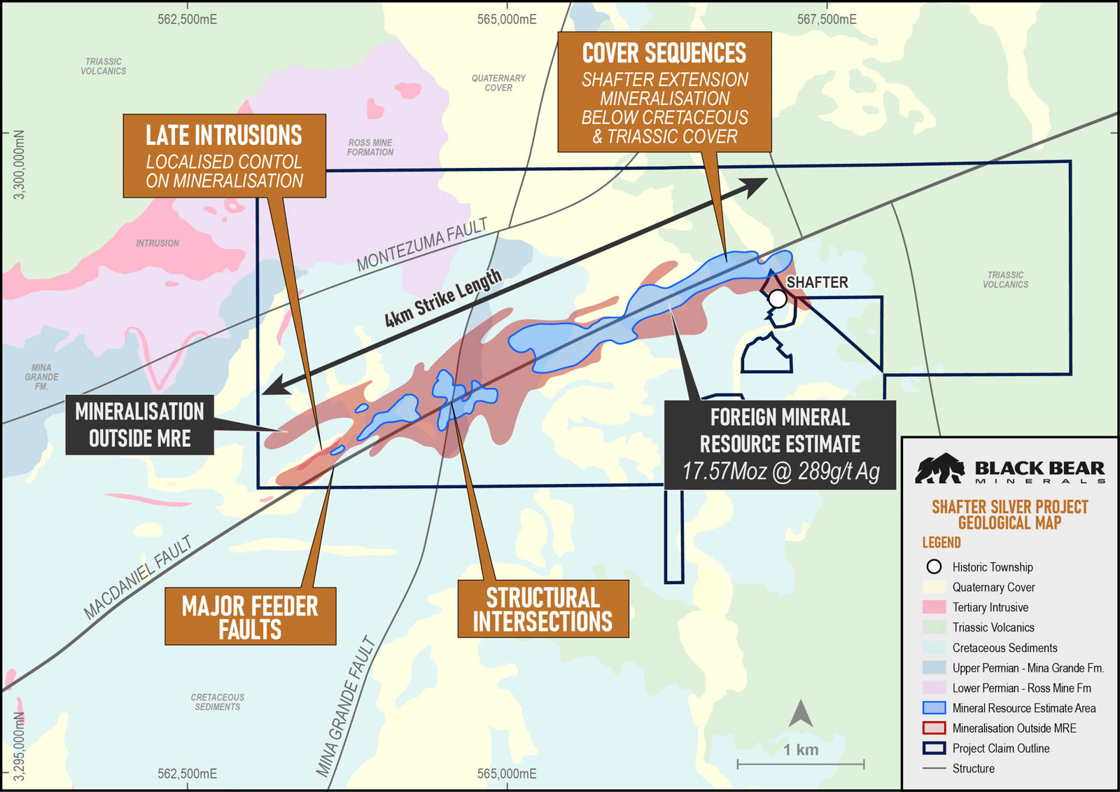
Figure 8: Geological Map of the Shafter Project, showing key structures and intrusive units in relation to the Shafter Deposit.
Foreign Mineral Resource Estimates
In December 2015, Mine Development Associates completed an NI 43-101 compliant technical report for the Shafter Project on behalf of Aurcana Silver Corporation. The following global Foreign Mineral Resource Estimate (MRE) has been converted from imperial to metric units for clarity, based on the 2015 report.
Measured
137
0.09
299
0.89
Indicated
137
1.01
314
10.17
Inferred
137
0.79
256
6.51
Total
137
1.89
289
17.57
Table 1: Shafter NI 43-101 Resource Estimate (2015)
The Mineral Resource Estimate at the Shafter Silver Project is a foreign estimate prepared in accordance with Canadian National Instrument 43-101. A competent person has not done sufficient work to classify the foreign estimate as a Mineral Resource in accordance with the JORC Code 2012, and it is uncertain whether further evaluation and exploration will result in an estimate reportable under the JORC Code 2012.
The 2015 estimate is the latest Foreign Mineral Resource Estimate reported for the Project. Foreign MREs for the Project have historically reported only silver mineralisation. As part of the Company’s maiden JORC 2012 MRE, Black Bear Minerals intends to incorporate all economically significant elements identified within the deposit, providing a more comprehensive understanding of the Project’s full value potential.

Figure 9: Long Section through Shafter Deposit showing maximum in-hole Ag . Red callouts represent underground drillhole intercepts, whilst blue callouts represent from-surface vertical drillhole intercepts.
The 2015 Foreign Mineral Resource Estimate of the Shafter Project largely excludes mineralisation of the historic Presidio Mine area (Figure 2). The 2015 block-diluted Foreign MRE was prepared for mine-restart planning under tight constraints, including removal of any block intersecting ≥5% underground workings, a 4.0oz/t (137g/t) Ag cut-off and a US$18.50/oz silver price, focusing on material that suited the existing infrastructure.
Next Steps
Following a comprehensive review of historical data at the Project, the Company is of the view that significant upside exists outside of the defined mineralised footprint of the Shafter Extension and Presidio Mine Area.
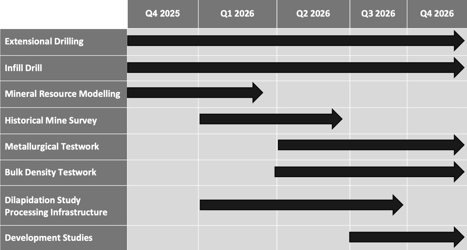
In the next 12-24 months, the Company intends to undertake a staged exploration and development program with a focus on delivering a maiden JORC Mineral Resource Estimate by increasing confidence levels through infill drilling, as well as testing regional targets through exploration drilling in areas surrounding the existing defined limits of the Shafter foreign MRE.
The Company will commence exploration in November 2025, including surface mapping and geochemical sampling to delineate targets for drill testing in late 2025. Initial exploration at the Project will focus on three key areas: northeast extensions to Shafter mineralisation, southwest extensions to the Presidio Mine, and from-surface, shallow drilling to determine open pit potential at a lower grade cut off, building on work by Aurcana (Figure 10).
Black Bear Minerals will follow up on significant results outside of all Foreign MREs, such as Aurcana’s significant silver-gold-lead intercept located 1km southwest of the historic Presidio Mine workings:
S-17-468:
7.3m @ 249g/t Ag, 1.4g/t Au, 1.8% Pb, 1.7% Zn from 137.8m, including
0.5m @ 1,875g/t Ag, 0.8g/t Au, 2.3% Pb, 4.8% Zn, and including
0.6m @ 9.6g/t Au, 31g/t Ag, 6.6% Pb, 0.5% Zn
Previous exploration at the Shafter Project primarily focussed on silver mineralisation, with little attention paid to other commodities. However, historical drill hole assay data, including exploration holes by Aurcana, show significant gold, zinc, and lead mineralisation associated with high-grade silver. The Company will commence a re-analysis program of historic drill core to delineate mineralised trends of all significant commodities at the Project, with a view of incorporating results into a maiden JORC Mineral Resource Estimate.
The historic Presidio Mine that operated until 1942 produced hand-sorted ore at an average grade of 521g/t Ag. Black Bear Minerals will commence a detailed survey of underground workings to build on current available data, including systematic sampling of drives, and complete follow-up drilling in order to quantify remaining mineralisation in the footprint of the historic Presidio Mine.
Alongside exploration activities, additional tests and measurements to refine bulk density and metallurgical factors will be undertaken, as well as maintaining required permits and undertaking a full dilapidation assessment to feed into future feasibility studies.
Subject to the outcomes of the activities described above, the Company plans to proceed through the standard development pathway to production, including but not limited to undertaking technical studies, beginning with a scoping study and then advancing to feasibility studies. The ability to bring the Shafter Project back into a production will be contingent on the outcome of the work listed above, as well as various other factors and prevailing market dynamics.

Figure 10: Exploration Targets for the Shafter Project.
Click through to see the Acquisition Announcement here
Forward-looking statements
This announcement may contain certain forward-looking statements, guidance, forecasts, estimates or projections in relation to future matters (Forward Statements) that involve risks and uncertainties, and which are provided as a general guide only. Forward Statements can generally be identified by the use of forward-looking words such as “anticipate”, “estimate”, “will”, “should”, “could”, “may”, “expects”, “plans”, “forecast”, “target” or similar expressions and include, but are not limited to, indications of, or guidance or outlook on, future earnings or financial position or performance of the Company. The Company can give no assurance that these expectations will prove to be correct. You are cautioned not to place undue reliance on any forward-looking statements. None of the Company, its directors, employees, agents or advisers represent or warrant that such Forward Statements will be achieved or prove to be correct or gives any warranty, express or implied, as to the accuracy, completeness, likelihood of achievement or reasonableness of any Forward Statement contained in this announcement. Actual results may differ materially from those anticipated in these forward-looking statements due to many important factors, risks and uncertainties. The Company does not undertake any obligation to release publicly any revisions to any “forward- looking statement” to reflect events or circumstances after the date of this announcement, except as may be required under applicable laws.

